
 Download Photo
)
)
)
)
)
)
)


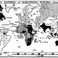
The British Empire in 1815 consisted of the thinly populated coastal river and lake regions of Canada, and a great hinterland of wilderness in which the only settlements as yet were the fur-trading stations of the Hudson Bay Company, about a third of the Indian peninsula, under the rule of the East India Company, the coast districts of the Cape of Good Hope inhabited by blacks and rebellious-spirited Dutch settlers; a few trading stations on the coast of West Africa, the rock of Gibraltar, the island of Malta, Jamaica, a few minor slave-labour possessions in the West Indies, British Guiana in South America, and, on the other side of the world, two dumps for convicts at Botany Bay in Australia and in Tasmania.
- Author
- The Project Gutenberg EBook of The Outline of History - Being a Plain History of Life and Mankind, by H. G. Wells published 1920
- Posted on
- Sunday 12 April 2020
- Dimensions
- 1500*881
- Tags
- Maps
- Visits
- 1407
- Downloads
- 31