The Pilgrims were familiar with Capt. John Smith’s account of a voyage in which he had surveyed th...") Captain John Smith’s Map of New England
Captain John Smith’s Map of New England
The Pilgrims were familiar with Capt. John Smith’s account of a voyage in which he had surveyed the coast from Cape Cod to Penobscot Bay in 1614. He had even offered his services as guide and military captain, but Myles Standish got the job. Undoubtedly they did bring with them his Description of New England (London, 1616), in which the following map was published. Capt. Smith, who had already gained some fame and fortune in Virginia, dedicated to Prince Charles this effort in which the term “New England” first appeared: “... it being my chance to range some other parts of America, whereof I here present your highness the description in a map, my humble suit [in original, “sure”] is you would please to change their barbarous names for such English, as posterity may say Prince Charles was their godfather.” Several English place-names were incorporated in the map, but posterity disregarded most of them, a noteworthy exception being “Plimouth.” Smith notes that the Indians called the site “... Accomack, an excellent good harbor, good land, and no want of any thing but industrious people,” recalling that “After much kindness, upon a small occasion we fought also with 40 or 50 of those [Indians]; though some were hurt and some slain, yet within an hour after, they became friends.” Although the Pilgrims were the first Europeans to establish a permanent colony in northeastern North...") Samuel de Champlain’s Map of Plymouth Harbor
Samuel de Champlain’s Map of Plymouth Harbor
Although the Pilgrims were the first Europeans to establish a permanent colony in northeastern North America, they did not come to an unknown land. As early as 1605, Samuel de Champlain had mapped Plymouth Harbor, in the course of a three-year expedition during which he explored the coast from Nova Scotia to Martha’s Vineyard. The quality of his detailed and accurate observations on the land and people appears in this map, and in his notes on the visit: “There came to us two or three canoes, which had just been fishing for cod and other fish which are found there in large numbers. These they catch with hooks made of a piece of wood, to which they attach a bone in the shape of a spear and fasten it very securely. The whole has a fang-shape, and the line attached to it is made out of the bark of a tree. They gave me one of their hooks, which I took out of curiosity. In it the bone was fastened on by hemp, like that in France, as it seemed to me, and they told me that they gathered this plant without being obliged to cultivate it, and indicated that it grew to the height of four or five feet. This canoe went back on shore to give notice to their fellow inhabitants, who caused columns of smoke to arise on our account. We saw eighteen or twenty savages, who came to the shore and began to dance. Our canoe landed in order to give them some bagatelles, at which they were greatly pleased. Some of them came to us and begged us to go to their river. We weighed anchor to do so, but were unable to enter on account of the small amount of water, it being low tide, and were accordingly obliged to anchor at the mouth. I went ashore, where I saw many others, who received us very cordially. I made also an examination of the river, but saw only an arm of water extending a short distance inland, where the land is only in part cleared. Running into this is merely a brook not deep enough for boats except at full tide. The circuit of the bay is about a league. On one side of the entrance to this bay there is a point which is almost an island, covered with wood, principally pines, and adjoins sandbanks, which are very extensive. On the other side, the land is high. There are two islets in this bay, which are not seen until one has entered, and around which it is almost entirely dry at low tide. This place is very conspicuous from the sea, for the coast is very low, excepting the cape at the entrance to the bay. We named it the Port du Cap. St. Louis...”. Coal is a combustible rock that was formed by the accumulation and partial decay of vegetation. When...") Reconstruction of coal-forming swamp
Reconstruction of coal-forming swamp
Coal is a combustible rock that was formed by the accumulation and partial decay of vegetation. When coal was forming millions of years ago, most of the state was a low coastal plain bordered on the west and southwest by a shallow sea. A large variety of plants grew in great swamps which covered this coastal plain. When the plants died, they accumulated in the swamps to form thick masses of peat that were eventually covered by shallow seas and buried beneath mud and sand. Periodically, the region was above sea level, new swamps developed, new peat deposits accumulated, and more sediments were laid down. This process occurred repeatedly until over 3,000 feet of sediments had been deposited. Then the sediments were slowly compacted and hardened so that sandstones, shales, limestones, and coals were formed. Extent of the main glacial advances which began with the Nebraskan (a—the oldest) and ended with t...") Extent of the main glacial advances
Extent of the main glacial advances
Extent of the main glacial advances which began with the Nebraskan (a—the oldest) and ended with the late Wisconsinan (f—the youngest). Diagram “d” shows the major stream development during the time between the Illinoian and the earliest Wisconsinan glaciers. The heavy lines on the diagrams indicate major stream valleys that were present during these times. a. Inferred limit of NEBRASKAN glaciation b. Inferred limit of KANSAN glaciation c. ILLINOIAN glacial advance d. SANGAMONIAN major drainage e. Maximum WISCONSINAN glacial advance f. Late WISCONSINAN Valparaiso front and Kankakee Flood Physiography is the study of the creation and gradual change of land surface forms (the landscape). ...") Physiographic provinces of Illinois
Physiographic provinces of Illinois
Physiography is the study of the creation and gradual change of land surface forms (the landscape). Thus, the land surface as we see it today in each of the physiographic provinces has had a particular history of development. Driftless Area Wisconsinan Moraines Illinoian Till Plain Mississippi River Wabash River Shawnee Hills Ohio River Austin, Nevada, six thousand feet above the sea. The metropolis of the Reese river district. Silver ...") Austin, Nevada, six thousand feet above the sea
Austin, Nevada, six thousand feet above the sea
Austin, Nevada, six thousand feet above the sea. The metropolis of the Reese river district. Silver first discovered at this point in July, 1862. Lynde Pyne watched the graceful movements of Leonie's fingers over the key board") The Typist
The Typist
Lynde Pyne watched the graceful movements of Leonie's fingers over the key board The two vertical lines are exactly the same length—measure them and see. Short lines turned back a...") Optical Illusion in dress
Optical Illusion in dress
The two vertical lines are exactly the same length—measure them and see. Short lines turned back at either end make one seem short; extended lines make the other seem longer.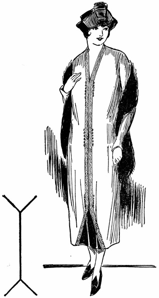
 These two illusions are almost duplicated in the dresses above. As a result one woman looks shorter ...") Optical Illusion in dress
Optical Illusion in dress
These two illusions are almost duplicated in the dresses above. As a result one woman looks shorter and heavier, the other taller and slenderer than she really is.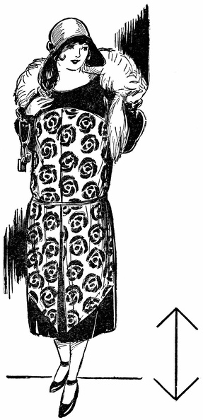
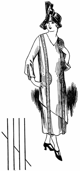
 These unbroken parallel vertical lines give the definite impression of height. This principle, used ...") Optical Illusion in dress
Optical Illusion in dress
These unbroken parallel vertical lines give the definite impression of height. This principle, used in the design of the dress above, lends it a pleasing slender appearance because no other lines interfere with the straight line effect.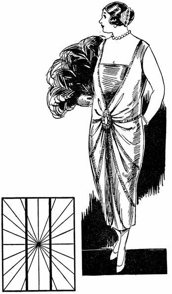
 Here, also, are two vertical parallel lines. They are straight—test them—but the other lines rad...") Optical Illusion in dress
Optical Illusion in dress
Here, also, are two vertical parallel lines. They are straight—test them—but the other lines radiating from the center, make them appear “bowed.” In the dress above a similar design makes the wearer appear stouter and heavier than she really is.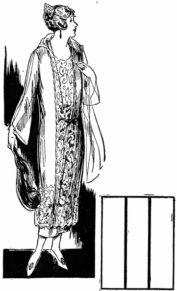
 These two diamond-shaped figures are exactly the same size. The crosswise line makes one seem wider,...") Optical Illusion in dress
Optical Illusion in dress
These two diamond-shaped figures are exactly the same size. The crosswise line makes one seem wider, the vertical line makes the other seem narrower.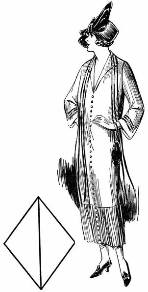
 Now note how these same principles used in the dresses above effect the apparent size and weight of ...") Optical Illusion in dress
Optical Illusion in dress
Now note how these same principles used in the dresses above effect the apparent size and weight of those wearing them, making one seem much stouter than the other.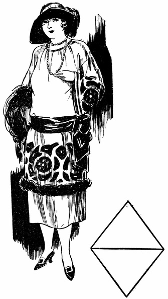
 The middle lines in the two small diagrams are the same length. But on the left, shorter accompanyin...") Optical Illusion in dress
Optical Illusion in dress
The middle lines in the two small diagrams are the same length. But on the left, shorter accompanying lines seem to shorten the one between. On the right longer accompanying lines seem to lengthen the one between.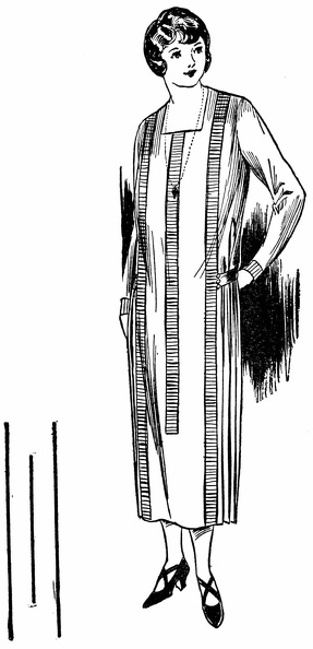
 Now see how the woman in the other picture has unknowingly emphasized her stoutness while the one in...") Optical Illusion in dress
Optical Illusion in dress
Now see how the woman in the other picture has unknowingly emphasized her stoutness while the one in this picure has properly gained a slender effect by using trimming in accordance with the principles of these optical illusions.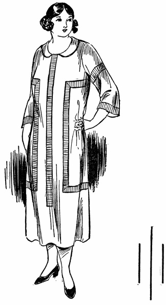
 The oblique line in the figure is made to seem longer and more graceful than the dress below by the...") Optical Illusion in dress
Optical Illusion in dress
The oblique line in the figure is made to seem longer and more graceful than the dress below by the parallel vertical lines of embroidery which intersect it and so emphasize its appearance of length and grace.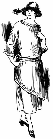
 When styles call for plaits, plaits may be used, but not in widening flares as shown here, rather in...") Plaits 1
Plaits 1
When styles call for plaits, plaits may be used, but not in widening flares as shown here, rather in slenderizing length lines as shown below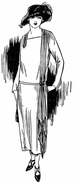
 Hats and shoes in these two pictures also illustrate incorrect and correct choice. The wide hat and ...") Plaits 2
Plaits 2
Hats and shoes in these two pictures also illustrate incorrect and correct choice. The wide hat and prominent straps below emphasize width and weight; the neat hat and cross-strap slippers here help to slenderize
 These two pictures illustrate improper and proper choice of fabrics for a stout figure. Above, the l...") Choice of fabric 1
Choice of fabric 1
These two pictures illustrate improper and proper choice of fabrics for a stout figure. Above, the large-figured material adds size, the fur trim shortens, the round beads shorten the neck. All conspire to emphasize weight.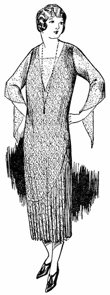
 Here a small all-over pattern minimizes size, the plaits and tassels lengthen, the necklace adds a s...") Choice of fabric
Choice of fabric
Here a small all-over pattern minimizes size, the plaits and tassels lengthen, the necklace adds a slenderizing touch. The appearance as a whole is graceful and youthful. Would you believe that the pattern of these two dresses is exactly the same? This illustrates how yo...") Two looks - same pattern
Two looks - same pattern
Would you believe that the pattern of these two dresses is exactly the same? This illustrates how you can vary a dress once you find the foundation lines that are becoming to you. One pattern can suffice for both a tailored and an afternoon dress, as you see both effects are pleasing in their slenderness. These two examples show how even a hat with drooping brim, if not too wide, can be worn by the stout...") Hats 1
Hats 1
These two examples show how even a hat with drooping brim, if not too wide, can be worn by the stout person if trimming is adeptly used to direct the vision upward and lend an illusion of height. Here trimming is used on two entirely different types of hats to give in each case added height to t...") Hats 2
Hats 2
Here trimming is used on two entirely different types of hats to give in each case added height to the figure and help in attaining a slenderizing appearance. Left—Hats with medium brims and high trimming are often becoming, especially if wide enough to avoid the pyramid effect. Right—High built trimming and delicate veils are advantageous where a double chin is the handicap. Note the diagonal line in the small diagram of the figure below. It is actually straight, but the ve...") Optical Illusion in dress
Optical Illusion in dress
Note the diagonal line in the small diagram of the figure below. It is actually straight, but the vertical lines which break it give it a “going-down-steps” appearance. This principle is used in the dress below—the two vertical panels of trimming break the line of the tunic and give the whole figure a more slender appearance than in the figure above.