8/20
Accueil / Albums / Mots-clés Place:America + Maps /
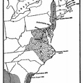
Map Showing Routes of Cartier, Champlain, and La Salle

 Télécharger la photo
)
)
)
)
)
)
)


Map Showing Routes of Cartier, Champlain, and La Salle, also French and English Possessions at the Time of the Last French War.
- Auteur
- Project Gutenberg's American Leaders and Heroes, by Wilbur Fisk Gordy Published 1907
- Ajoutée le
- Mardi 17 Mars 2020
- Dimensions
- 1376*860
- Mots-clés
- Century:17th, Explorer, Maps, Place:America, Place:France
- Albums
- Visites
- 2073
- Téléchargements
- 77