Télécharger - Tailles de photo
XXS - minuscule
(240 x 188)
XS - très petit
(412 x 324)
S - petit
(550 x 432)
M - moyen
(757 x 594)
L - grand
(963 x 756)
Original
(975 x 765)
11/26
Accueil
/
Albums
/
The First printed map of England
Miniatures
Précédente
Suivante
Tailles de photo
Tailles de photo
✔
XXS - minuscule
(240 x 188)
✔
XS - très petit
(412 x 324)
✔
S - petit
(550 x 432)
✔
M - moyen
(757 x 594)
✔
L - grand
(963 x 756)
✔
Original
(975 x 765)
diaporama
Télécharger
Télécharger la photo
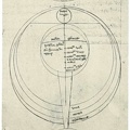
The First printed map of England
Auteur
Studies in the History and Method of Science
Editor: Charles Singer
Published in 1917
Available from gutenberg.org
Ajoutée le
Mercredi 4 Novembre 2020
Dimensions
975*765
Mots-clés
Maps
Albums
Places
/
Europe
/
Britain
Visites
1344
Téléchargements
51
Propulsé par
Piwigo

 Télécharger la photo


)
)
)
)
)
)